Download our Excel template of vehicles and fill it with the list of drivers that will make the routes. It is very important to keep the cell format and do not change the name of the columns.
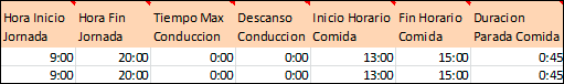
1. Driver’s schedule
- In each row indicate a driver's working hours.
- We recommend some flexibility for the breaks ("Start Meal Break", "End Meal Break" "Duration Meal Break") to obtain a better planning. In this example, the meal (lasting 45 minutes) can be placed within a 2-hour time slot (from 13h to 15h). So, if for example two clients are very close, Routing Reparto will take this into account and plan the driver's break once the driver visits those customers.
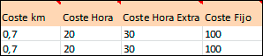
2. Transportation costs
- "Hour cost" indicates an hour's cost, within the schedule
- "Overtime Cost" indicates the cost of an overtime hour
- "km Cost" indicates the cost of transportation (fuel, vehicle amortization, ...)
- "Fixed Cost" indicates the daily cost of a driver/vehicle and is the same daily amount
When the planning is completed, you will have the total costs of the routes of your business activity synthesized on the "Statistics" tab: Total km, total cost, driving hours, hours of service with the customer, cost of the working hours, overtime costs, ...
3. Addresses of vehicles
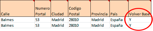
- Indicate the name of the vehicle or driver
- Enter the complete address (name, street number, city, zip code, state, country)
- You must fill in all fields and avoid street names with errors
-
"Return Base" has 3 very interesting possibilities:
- "Y": the vehicle ends its route at the departure base, at the end of its working day (before 20h, in our example)
- "N": the vehicle ends its route at the last client visited, at the end of its working day (before 20h, in our example)
- "Y" adding a second address: the vehicle ends at a second base or at the driver’s home, at the end of its working day
After you add the vehicles, Routing Reparto geolocates the addresses and assigns geographical coordinates. Then, you can check the quality of the geolocalization on the display:
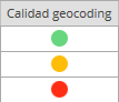
- Green: Correct location. You don´t have to do anything
- Yellow: Only the street is located. This vehicle's route will be planned but the vehicle is located at the start of the street. Use only one number (e.g. 12 in stead of 12-32)
- Red: The street or the city are not located. You should revise the address or use coordinates.
4. Resolve addresses poorly located
Routing Reparto has two tools to manually resolve addresses: moving them on the map and correcting the texts. After making the changes, you can download the list of coordinates to Excel (and move forward with the planning).
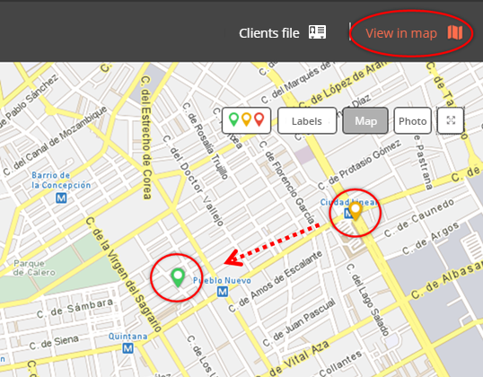
A: Move them on the map
- Click on "View on map"
- On the map, click once on the wrongly located address and move it to the correct location.
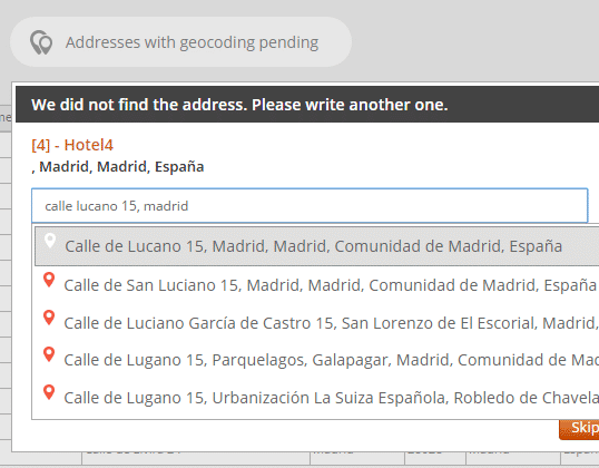
B: Changing the texts
- Click on "Addresses with geocoding pending"
- If we found similar addresses. Please choose one from the list
- If you can´t find the address in the list, please write another one
5. Using geographical coordinates, the solution to problems with geocoding addresses
For complicated postal addresses, we recommend using geographical coordinates X-Y (columns "X Origin Coord" and "Y Origin Coord"). The main causes of problems with postal addresses tend to be:
- Some field is empty: "Street", "Number", "City", "Postal Code", "Province" or "Country" are empty.
- Mistyped or incomplete address: for example the street name is abbreviated ("St James W", instead of "Saint James Walk").
- Unspecific or remote address: like for example, "Industrial Park West Side" or "Smithfield Market".
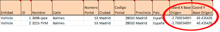
To begin with, you must download the "Vehicles" template with "Coordinates". We strongly recommend using this new Excel template but you can also add new columns to your old Excel template. Always remember that it is very important to keep the format of the cells and do not change the name of the columns
Remember that your Excel can have rows with postal addresses and rows with coordinates. If a row has both an address and coordinates, Routing Reparto will only use the coordinates.
How to look for coordinates
Routing Reparto uses the maps of Cercalia.com, a powerful map server with the cartography of TomTom. We recommend that you use it to resolve addresses or find coordinates.
1. To begin searching for coordinates, click this web address:
http://www.cercalia.com/api/examples/demoBasic.html
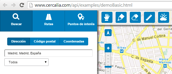
2. Type the address, e. g.: "Nottingham Place 58, Paddington, Westminster, London, United Kingdom".

3. By right-clicking on the map you get the same result: it displays the address and the coordinates.
The map geocodes the vehicle and displays its coordinates: X-Y: -0,153225638 51,522080985

Routing Reparto is available in 20 countries, for a total of 800 million inhabitants: Germany, Argentina, Austria, Belgium, Brazil, Chile, Colombia, Denmark, Spain, France, Netherlands, England, Ireland, Italy, Luxembourg, Mexico, Portugal, Switzerland and Uruguay.